Record-Low Amazon Deforestation Came With a Smaller Share of Slow Collapse
Brazil's INPE confirmed to Hooray News its record-low 3,335 km² Amazon estimate, and an INPE chart shows slow forest collapse fell to 22% of the loss.

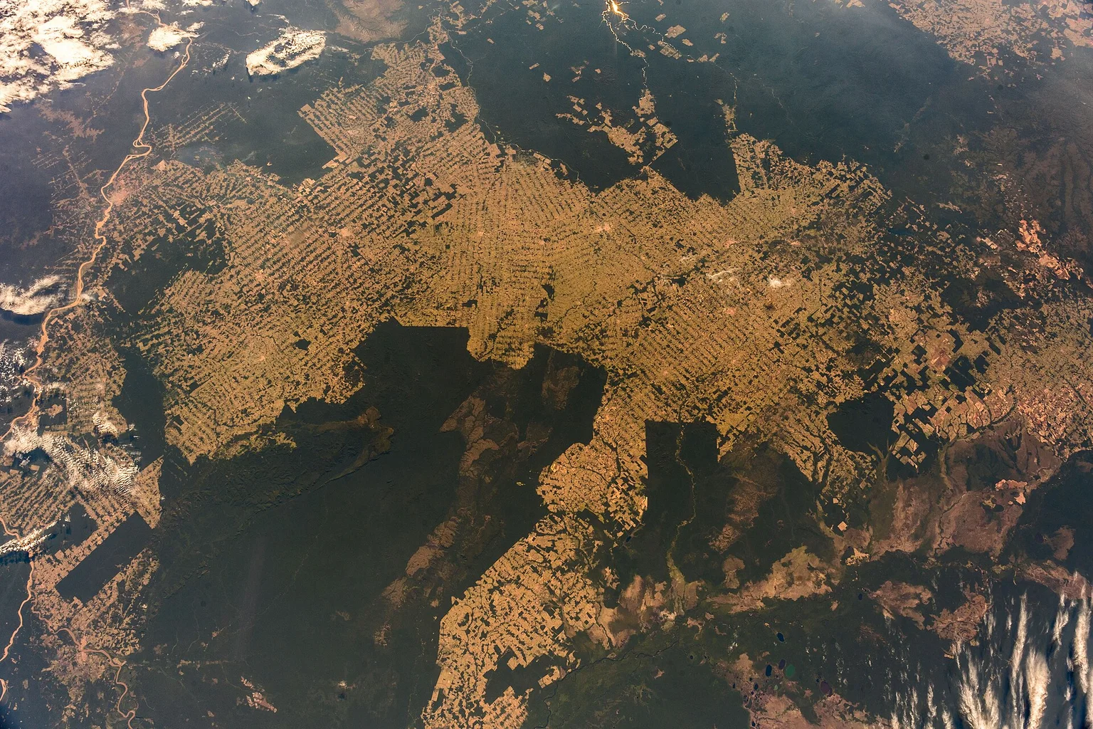
Amazon deforestation hit a record low this year, and a chart from Brazil’s space research agency suggests the loss also changed shape. A smaller share came from forest slowly collapsing after logging and fire, and a larger share came from old-fashioned clear-cutting, according to figures Brazil’s National Institute for Space Research (INPE) sent Hooray News.5
On Oct. 24, Hooray News reported that INPE’s PRODES satellite system found about 3,335 square kilometers of Amazon deforestation between August 2025 and July 2026. That is about 42% below the year before and the lowest since the series began in 1988.5 Asked whether those numbers hold up, Cláudio Almeida, coordinator of INPE’s BiomasBR Monitoring Program, told Hooray News in an email relayed by INPE’s press office on Oct. 29: “Yes, they are correct.” (translated from Portuguese)5
That figure is still a preliminary estimate. It is based on priority satellite images and is being compared with a consolidated rate of 5,731 square kilometers for the previous year. According to INPE’s release, the consolidated 2026 rate, based on all images, will come in the first half of 2027.1
Clear-cutting vs. progressive degradation in the Amazon
PRODES counts forest as deforested when its canopy is completely gone. That can happen in one go, by clear-cutting, or at the end stage of progressive degradation, when repeated damage eventually removes the canopy entirely.14
Almeida explained the shift in how INPE sees the problem:
“In the past this suppression was practically 100% clear-cutting. In recent years there have been growing cases where the forest collapses due to the repeated occurrence of logging, degradation and forest fires.”
That is why INPE has recorded which type each case is since 2022, Almeida said.5
In the chart INPE sent with his answers, the share recorded as progressive degradation climbed from 7.3% in 2022 to 20.1% in 2023, 28.5% in 2024 and 37.3% in 2025. In 2026 it fell to 22%, with the remaining 78% recorded as clear-cutting.5 The chart has no legend, so that reading rests on Almeida’s explanation of it.
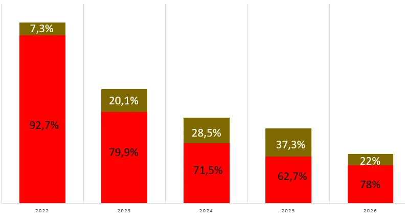
INPE’s earlier published estimates were close to the chart but not identical: 7.23% for 2022, 20.49% for 2023 and 27.41% for 2024 in its 2024 technical note, which labeled them preliminary.4 At the 2025 announcement, Almeida showed degradation at about 38% of that year’s total, and Agência Pública linked that degradation to fire.3
What the numbers leave out
Fire is the big caveat. PRODES measures August through July, a window chosen because cloud cover is lower in the middle of the year.2 That means fires in October 2026 fall outside this count. INPE also notes that fire can damage forest without all of the burned area being classed as deforestation.1
Hooray News also asked about DETER, INPE’s faster alert system, which flagged 2,874 square kilometers over the same 12 months. Almeida said that number stands, but DETER is built for speed: it uses satellite images at 60-meter resolution to give enforcement agencies quick information.5
“The important thing to keep in mind is that the precise deforestation figure is the one that comes from PRODES; DETER serves as an indicator of trends, besides, of course, providing real-time information for enforcement.”
Where the drop showed up
The biggest losses were still in Pará, at 1,130 square kilometers (down from 2,064), Mato Grosso, at 849 (down from 1,593), and Amazonas, at 525 (down from 979). Roraima was the exception, essentially flat at 286 square kilometers against 285 the year before.1 For scale, annual losses peaked at nearly 30,000 square kilometers in the mid-1990s.2
The Cerrado also fell 23.8% to 5,516.69 square kilometers, the lowest since its series began in 2001.1
What’s next for PRODES
Mapping a rainforest from space has an obvious weather problem. Almeida said INPE has spent the past two years adding high-performance cloud computing and AI-based algorithms, and is automating its classification step and expanding its auditing.5 “Radar imagery has been incorporated to cover all of the Brazilian biomes, even in periods when there is cloud cover,” he said.5
INPE also announced R$147.6 million (about $27 million) from the Amazon Fund for SIM-Biomas, a project that will use AI to combine PRODES and DETER and produce PRODES data throughout the year, not just once a year.1 The agency’s maps and data are public on its TerraBrasilis platform.
Cláudio Almeida answered Hooray News’s questions in Portuguese by email on Oct. 29, 2026. Quotes in this story are our translations.
Did this make your day? Give it a cheer.
Sources
- Brasil alcança menores taxas de desmatamento da série histórica na Amazônia e no Cerrado INPE (Instituto Nacional de Pesquisas Espaciais), 2026-10-16
- Deforestation in Brazil's Amazon falls to all-time low RTÉ (Reuters report), 2026-10-17
- Amazônia alcança a terceira menor taxa de desmatamento da história Agência Pública, 2025-10-30
- Nota Técnica: estimativa da taxa de desmatamento Prodes Amazônia 2024 INPE, 2024-11-01
- Email interview with Cláudio Almeida, coordinator of the BiomasBR Monitoring Program, Brazil's National Institute for Space Research (INPE) (Oct. 29, 2026) Hooray News interview, 2026-10-29